 Hiking
 Login
Login More
More EN
EN Premium

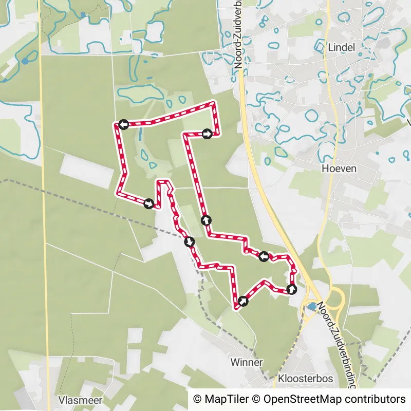
Along the Cicindria
6.9 km
This route largely follows the trail of the Landscape Walk Cicindria from Wandelen in Limburg. I chose to start at Brewe... read more

© Stadia Maps © OpenStreetMap contributors, © NodeMapp
Put on your hiking shoes and discover the most beautiful hiking routes in Limburg! You will also see all places where hiking nodes are currently available.
Below you will find the latest hiking trails in Limburg offered by official tourism organisations or by verified users of our platform.
Pathfinders are hikers who share their hiking adventures in Limburg with you.
Looking for an adventure? Try our 'Surprise Me' feature! Enter your preferences below, and we will suggest a number of hikes using the hiking nodes in Limburg. The routes are calculated in real-time using the hiking node network.
6.9 km
This route largely follows the trail of the Landscape Walk Cicindria from Wandelen in Limburg. I chose to start at Brewe... read more

10 km
This top hike starts at the 'National Park Visitor Center' in Maasmechelen, where you will find ample parking. The two p... read more

7.9 km
This walk explores the hilly landscape between Groot- and Klein-Gelmen in Haspengouw. At the church of Groot-Gelmen, you... read more

9.7 km
This beautiful walk starts at the Mechelse Heide entrance of the Hoge Kempen National Park in Maasmechelen. There is amp... read more


10.9 km 5/5
This walk in the beautiful Limburg takes you through National Park Bosland. In October 2023, this area was even awarded ... read more

6.5 km
Nature knows no boundaries, and certainly not in northern Limburg. A 600-hectare oasis of heathland, fens, forests and g... read more

5 km
Whether you're visiting Hasselt for the first time or already know it like the back of your hand, the Taster Speechmaker... read more

6 km
Gerhagen forms the green lung of Tessenderlo and lies at the crossroads of Limburg, Flemish Brabant and Antwerp. Togethe... read more

20 km 4/5
Grease your calves, lace up your hiking boots, strap on your backpack and traverse cow pastures, streams and scrubland w... read more

12 km
The center of Tessenderlo is an ideal place to start a hike along the hiking network de Merode. You start from the cozy ... read more

7.5 km
This hike takes you to Gerhagen nature reserve, Flanders' first official silence area. And in Gerhagen, there you find n... read more

11 km 5/5
You notice here that the flat Kempen passes into the hilly Hageland. And that makes for an area with its own character. ... read more

9.5 km 4.5/5
This beautiful hike begins in the center of Kanne. You quickly leave this charming little village and cross the border w... read more

7.7 km
This wooded walk takes you on a journey through time. You will learn about local history through the beautiful lanscape ... read more

7.6 km
Parking: Corda Campus, Research Campus Hasselt. Signage: Walking app or GPS. Walk mostly on paved roads, the 2 km of u... read more


7 km
Parking: Sint-Janstraat, near the church of Thiewinkel (Lummen). Signage: Walking app or GPS. Nice walk, among others, t... read more


6.5 km
The starting point is the spacious parking lot at the dog school. We dive under the roundabout and then immediately find... read more


6.8 km
On and around the site of the Sevensmolen in Pelt, you can take this beautiful walk. Parking is available at the mill mu... read more


8.2 km
Parking: Parking next to Napoleonweg (near 82A) in Pelt. Signage: Walking app/GPS. Walking through the Bosland National ... read more


6.9 km
Parking: Sports Hall Kneippstraat Genk. Signage: Walking app/GPS. The walk covers the first 2.3 km on paved roads, follo... read more


8.5 km
Parking: Zepperen Sint-Genovevakerk. Signage: Hexagonal signs with a red flower. If you'd like to enjoy this beautiful p... read more


15.6 km
Parking: Central Cemetery Borgloon, Lambertusstraat. Signage: Hiking app/Virtual Junctions. Beautiful hilly walk (140 me... read more


7.1 km
Parking: C-Mine Winterslag. Signage: Walking app / Junction points. Nice varied walk. First the mining heritage of Winte... read more


7.6 km
Parking: Kneippstraat Genk (football field Bokrijk Sport) Signage: Walking app/Nodes. Leisurely walk to Provincial Domai... read more


11.5 km
We did this walk on 03/23/2025 (14,342 steps). The route starts at junction 139, on the hill where the Leyssens mill onc... read more


10.5 km
Markings in both directions: yellow hexagon on a white background We took this walk on 03/20/2025 (13,434 steps). This i... read more


8.7 km
Parking: Parking Stiemerheide, Wiemesmeerstraat 105 Genk Signposting: Hiking app/GPS. You need to cross the busy Europal... read more


9.9 km
We did this walk on 18/03/2025 (12,269 steps). This route is signposted in both directions with a red triangle and with ... read more

| region/place | km hiking network | |
|---|---|---|
| Alken | 12 km 12 | |
| As | 61 km 61 | |
| Beringen | 42 km 42 | |
| Bilzen-Hoeselt | 105 km 105 |
The Route Planner Pro has changed a bit on our new website. The ability to plan routes that deviate from the hiking network is now integrated into our node planner (continue reading below image):

If you open our route planner, you can press the magnet symbol in the upper right corner. If you then choose Offgrid (auto) (automatic route planning) or Offgrid (manual) (connecting places manually), you can select places on the map and plan a route that deviates (partially or completely) from the hiking network.
You can switch between Node and Offgrid mode to create a route that runs partly along nodes and partly away from the node network.
The Route Planner Pro has changed a bit on our new website. The ability to plan routes that deviate from the bicycle network is now integrated into our node planner (read more below image):

If you surf to our route planner, you can press the magnet symbol in the upper right corner. If you then choose Offgrid (auto) (automatic route planning) or Offgrid (manual) (connecting places manually), you can select places on the map and plan a route that deviates (partially or completely) from the biking network.
You can switch between Node and Offgrid mode to create a route that runs partly along nodes and partly away from the node network.

Are you sure you want to log out?
With this QR-code or text code you can login to our app. Open the login screen of the NodeMapp Hike app or NodeMapp Bike app and press the button with the QR-code. In the same screen, you can also enter the text code (case sensitive!) if you prefer.
Time remaining to log in with this code:
01:00


 Upgrade to Premium Plus