 Hiking
 Login
Login More
More EN
EN Premium
Routen
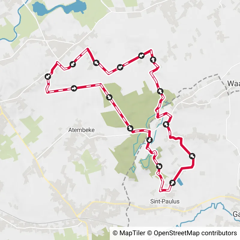
Sint-Lievens-Houtem, Belgium
Cotthem and Oude Heerweg hiking trail
10.8 km 4.7/5
Numerous country and forest roads and well-preserved hollow paths lead you through the valley of the Cotthem brook, the ... read more

© Stadia Maps © OpenStreetMap contributors, © NodeMapp
Put on your hiking shoes and discover the most beautiful hiking routes in Vlaamse Ardennen! You will also see all places where hiking nodes are currently available.
Below you will find the latest hiking trails in Vlaamse Ardennen offered by official tourism organisations or by verified users of our platform.
Pathfinders are hikers who share their hiking adventures in Vlaamse Ardennen with you.
Looking for an adventure? Try our 'Surprise Me' feature! Enter your preferences below, and we will suggest a number of hikes using the hiking nodes in Vlaamse Ardennen. The routes are calculated in real-time using the hiking node network.
10.8 km 4.7/5
Numerous country and forest roads and well-preserved hollow paths lead you through the valley of the Cotthem brook, the ... read more

27.8 km
This day trip takes you from the station of Lierde all the way to that of Ronse. On the way you cross the most famous fo... read more

22.4 km
On this brisk hike, you'll tick not one, two, but three forests off your hiking bucket list! Explore the Brakelbos, the ... read more

14.9 km
On this hiking trail you step from the station of Zandbergen to the station of Geraardsbergen. Along the way you will pa... read more

19 km
To explore Bos t' Ename and its heritage does not require much convincing, and the Volkegembos knits another green offsh... read more

16.5 km 3.5/5
This walking route of 16.5 km sends you along six art locations in Maarkedal. You will pass a cast of Tom Boonen's legs ... read more

15.3 km
This hike is one for those with choice stress, as it is the ideal combination between culture and nature. Start in the h... read more

12.6 km 3/5
Depart from the village of Nieuwenhove (part municipality of Geraardsbergen), for a walk in the sloping landscape and th... read more

5.9 km 3.8/5
Depart from the picturesque Sint-Goriks-Oudenhove towards the Steenbergse Bossen nature reserve. A varied walk with nume... read more

6.9 km 4/5
In the mid-18th century, a certain Jan de Lichte wandered around the neighborhood of Velzeke. Driven by poverty, he and ... read more

2.9 km
A walk through the city of Oudenaarde in the heart of the Flemish Ardennes. Start on the market square at the beautiful ... read more

8.9 km 2.5/5
In the Scheldt Valley between Nederename and Nederzwalm lies a string of small and large nature reserves where walking i... read more

36.9 km 4.3/5
Between the Flemish Ardennes and the equally beautiful Pays des Collines in Hainaut, the invisible language border meand... read more

28.7 km 3.8/5
Low sun, white wisps of mist among the green hills: early in the morning the Flemish Ardennes are at their most beautifu... read more


12.9 km
Departure: Sint-Gangulphus Church - village - Oosterzele Walk in Oosterzele to the Ettingebos, Birth Forest, Lange Brouc... read more


12.1 km
Herzele is a place between Zottegem and Aalst on the edge of the Flemish Ardennes. This flat walk starts at walking junc... read more


9.9 km 5/5
This varied walking loop leads through forests and rural roads in a lesser-known hiking area between Zottegem and Sint-L... read more


18.3 km 4/5
With this loop, you fully explore the Zwalm region and the Flemish Ardennes. The walk starts on the Jan de Lichte trail ... read more


15.4 km
This is a real calf-burner, but a beautiful hike in the heart of the Flemish Ardennes on the territory of Ronse and Maar... read more


9.4 km
🍃My Summer Walk in the Flemish Ardennes☀️ Route with junctions🔢 A lot of variety with boardwalks and especially beauti... read more


15.4 km
Parking: Munkzwalm, Zuidlaan (behind the post office) Signposting: Junction points. Along the Zwalmbeek and through the ... read more


10.8 km
Departure Parking Ter Biestmolen - Biestmolenstraat 18 - Zwalm The train station of Sint-Denijs-Boekel is located 1.5 km... read more


13.4 km
Loop of 13.5 km starting from walking junction 1 at the Zwalm mill in Munkzwalm. You can also park there. In the directi... read more


8.3 km 4.5/5
Own tour with junction points that takes you through beautiful nature, including the Everbeek forests, Livierenbos, and ... read more


12.3 km
Departure: Heirbaan 137 - Galmaarden A varied walk across the fields and in the Raspaillebos. The Raspaillebos forms a w... read more

16 km
A walk along the language border. On this walk, we encounter several houses beautifully decorated with artworks, the mos... read more


11.9 km
Departure: Heirbaan 135, Galmaarden We walk directly into the Raspaillebos and then continue to the Provincial Domain De... read more

32.3 km
From Onze-Lieve-Vrouw-Lombeek in Pajottenland, you explore both the tangible and natural heritage. You pass by the Castl... read more

The Route Planner Pro has changed a bit on our new website. The ability to plan routes that deviate from the hiking network is now integrated into our node planner (continue reading below image):

If you open our route planner, you can press the magnet symbol in the upper right corner. If you then choose Offgrid (auto) (automatic route planning) or Offgrid (manual) (connecting places manually), you can select places on the map and plan a route that deviates (partially or completely) from the hiking network.
You can switch between Node and Offgrid mode to create a route that runs partly along nodes and partly away from the node network.
The Route Planner Pro has changed a bit on our new website. The ability to plan routes that deviate from the bicycle network is now integrated into our node planner (read more below image):

If you surf to our route planner, you can press the magnet symbol in the upper right corner. If you then choose Offgrid (auto) (automatic route planning) or Offgrid (manual) (connecting places manually), you can select places on the map and plan a route that deviates (partially or completely) from the biking network.
You can switch between Node and Offgrid mode to create a route that runs partly along nodes and partly away from the node network.

Are you sure you want to log out?
With this QR-code or text code you can login to our app. Open the login screen of the NodeMapp Hike app or NodeMapp Bike app and press the button with the QR-code. In the same screen, you can also enter the text code (case sensitive!) if you prefer.
Time remaining to log in with this code:
01:00

 Upgrade to Premium Plus