 Hiking
 Login
Login More
More EN
EN Premium

Toerisme Vlaams-Brabant
Tervuren, Belgium
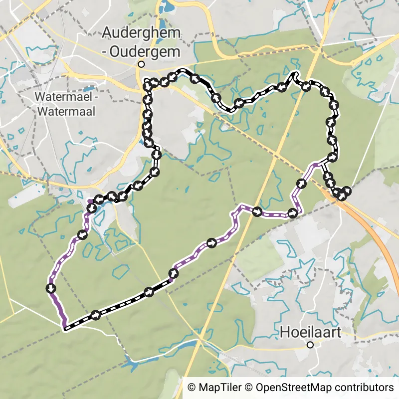
Serristenwandeling
11.6 km 3.2/5
Explore the slow roads of Eizer and Duisburg past some authentic serrist homes. You can start from Duisburg (Pachthof St... read more


© visittervuren.be
Below you will find the latest hiking trails in Tervuren offered by official tourism organisations or by verified users of our platform.
Pathfinders are hikers who share their hiking adventures in Tervuren with you.
Looking for an adventure? Try our 'Surprise Me' feature! Enter your preferences below, and we will suggest a number of hikes using the hiking nodes in Tervuren. The routes are calculated in real-time using the hiking node network.
The Route Planner Pro has changed a bit on our new website. The ability to plan routes that deviate from the hiking network is now integrated into our node planner (continue reading below image):

If you open our route planner, you can press the magnet symbol in the upper right corner. If you then choose Offgrid (auto) (automatic route planning) or Offgrid (manual) (connecting places manually), you can select places on the map and plan a route that deviates (partially or completely) from the hiking network.
You can switch between Node and Offgrid mode to create a route that runs partly along nodes and partly away from the node network.
The Route Planner Pro has changed a bit on our new website. The ability to plan routes that deviate from the bicycle network is now integrated into our node planner (read more below image):

If you surf to our route planner, you can press the magnet symbol in the upper right corner. If you then choose Offgrid (auto) (automatic route planning) or Offgrid (manual) (connecting places manually), you can select places on the map and plan a route that deviates (partially or completely) from the biking network.
You can switch between Node and Offgrid mode to create a route that runs partly along nodes and partly away from the node network.


 Upgrade to Premium Plus