Loading...

From the Bergmolen to Hooidonk

automatic translation

16 km • Zandhoven

800 0 0/5

16 km 0.0 km 0.0 km
10 km
© OpenStreetMap contributors, Tracestrack

route offered by

Jan Theunis

Icon starting point Addresse starting point (approximate)

Molenheide 64, 2242 Zandhoven, BE

Icon type signage of route signage

The route is fully signposted with nodes.

62.2 m 73.8 m 34.6 m 6.9 m These values indicate respectively the number of meters to rise, the highest and the lowest point in meters.
Atmosphere image 1 of route From the Bergmolen to Hooidonk Atmosphere image 2 of route From the Bergmolen to Hooidonk Atmosphere image 3 of route From the Bergmolen to Hooidonk
© Jan Theunis

Icon description route Description

Parking: Molenheide 65, Zandhoven (at the mill)

Signage: Hiking app/Junction points.

Quiet walk over mostly paved roads. At junction point 82, you are instructed to follow a detour to junction point 81, but you can simply go to junction point 81 through the mini golf park.

On sunny days, there is little shade.

Rest bench(es): among others after 1.3 km / 4.3 km / 7.9 km / 8.4 km / 9.5 km / 9.9 km and 11.8 km.

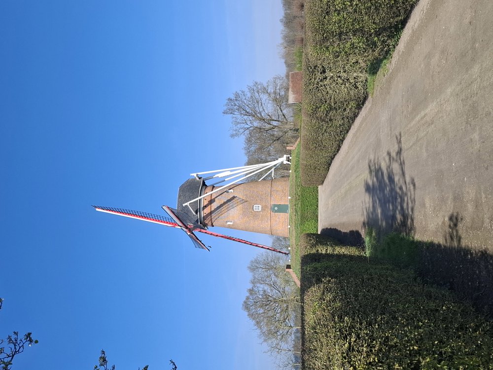
Points of interest: Bergmolen.

automatic translation

Icon nodes to follow nodes to follow

Image node TP
0 km
Image node 11
0.3 km
Image node 14
1.2 km
Image node 15
1.6 km
Image node 16
2.5 km
Image node 7
2.7 km
Image node 5
3.5 km
Image node 6
3.8 km
Image node 2
4.3 km
Image node 3
5.2 km
Image node 10
6.7 km
Image node 9
6.8 km
Image node 8
7.3 km
Image node 83
7.5 km
Image node 82
7.7 km
Image node 81
8.5 km
Image node 84
9.2 km
Image node 85
9.5 km
Image node 86
9.9 km
Image node 87
10.4 km
Image node 34
11.1 km
Image node 34
11.2 km
Image node 57
13 km
Image node 55
13.2 km
Image node 56
13.3 km
Image node 13
15.4 km
Image node 12
15.7 km
Image node TP
16 km
This route does not have any reviews yet. Be the first!
Rate route!

Which POI do you want to show on the map?

Experimental hiking network
Unsigned icon

The route you have chosen runs (partly) along an experimental virtual hiking node network (the blue-coloured nodes and sections on the map).

You must be logged in to plan routes here.

Experimental hiking network
Unsigned icon

The route you have chosen runs (partly) along an experimental virtual hiking node network (the blue-coloured nodes and sections on the map).

These routes are not controlled in the field. Before you start hiking here, take a minute to read what an experimental hiking node network is and what rules you should follow when hiking here.

By clicking 'Accept all cookies,' you agree to the use of cookies for an enhanced user experience, website traffic analysis, and personalized advertisements. Cookie policy